City of Oakwood - Self Guided Bike Tour
Points of Interest
- City Admin Offices
- Harman School
- Oakwood Jr/Sr High
- Mack/Hummon Field
- Foell Public Works Center
- Creager Field Dog Park
- Long - Romspert Homestead
- Smith Gardens
- Orchardly Park
- Elizabeth Gardens
- Loy Gardens
- Paw-Paw Camp
- Houk Stream
- Centennial Park
- Fairridge Park
Accessible view
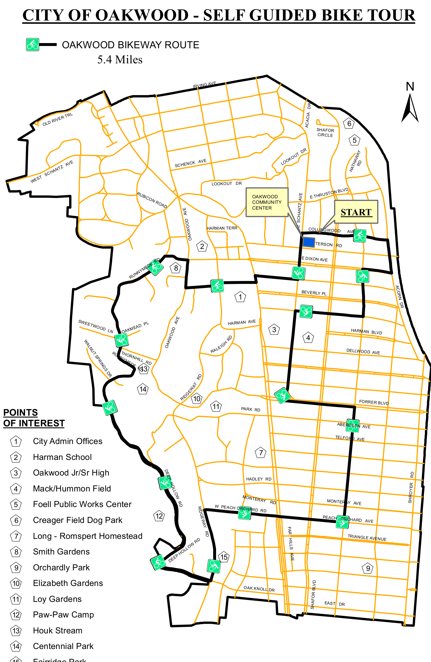
The map shows the 5.4-mile Oakwood Bikeway Route through the City of Oakwood. Follow the black route line from the marked START on the east side, just southeast of the Oakwood Community Center, near Collingwood Ave and Terson Rd. The line travels west through the central streets, then turns south through the western and southern portions of the map before returning north and east toward the START area. The map labels route-area streets including E Dixon Ave, Beverly Pl, Harman Blvd, Dellwood Ave, Forrer Blvd, W Peach Orchard Rd, Hadley Rd, Oak Knoll Dr, Schantz Ave, E Thurston Blvd, and Shroyer Rd; the orange lines are the surrounding street network.
Numbered locations and their map relationships
The numbered shields identify these locations in relation to the route and street network:
- 1 — City Admin Offices: central, just west of the route's central north–south segment.
- 2 — Harman School: north-central, west of the center of the route.
- 3 — Oakwood Jr/Sr High: east-central, beside the route's eastern central segment.
- 4 — Mack/Hummon Field: east-central, southeast of point 3.
- 5 — Foell Public Works Center: northeast, below point 6.
- 6 — Creager Field Dog Park: far northeast, above point 5.
- 7 — Long - Romspert Homestead: south-central, west of the route.
- 8 — Smith Gardens: west-central, near the western portion of the route.
- 9 — Orchardly Park: southeast, east of the southern route.
- 10 — Elizabeth Gardens: south-central, west of point 11.
- 11 — Loy Gardens: south-central, just east of point 10.
- 12 — Paw-Paw Camp: southwest, beside the western/southern portion of the route.
- 13 — Houk Stream: southwest, along the western portion of the route.
- 14 — Centennial Park: southwest-central, north of point 13.
- 15 — Fairridge Park: south-central, east of point 13 and south of points 10 and 11.