HIGHWAY SAFETY PROGRAM
EXISTING CONDITIONS
- Intersection skew of 60 degrees and 6 approaches
- Signalized traffic control, advance warning signs, calculated clearance intervals, and a high visibility crosswalk to improve safety performance
- Far Hills Avenue operating speeds of 42 MPH
- Vulnerable road users are a significant component
- Injury crash rate (29%) above statewide average (26%)
COUNTERMEASURES
- Convert signalized intersection to a peanut shaped roundabout
- Increase visibility of pedestrians by installed raised crosswalks and pedestrian hybrid beacons (PHBs)
PROPOSED COUNTERMEASURE
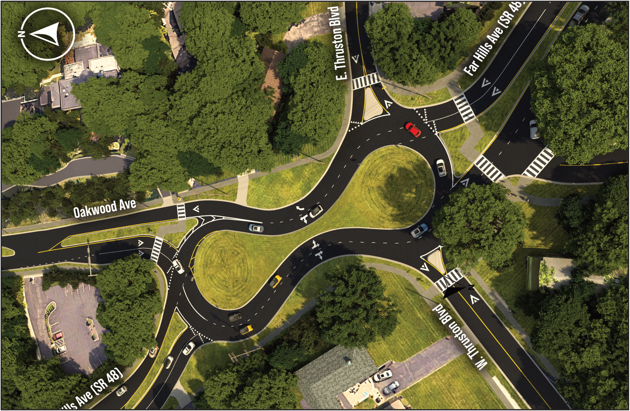
APPLICATION SCORING
| Category | Scoring Value | Points Awarded | Points Possible |
|---|---|---|---|
| Ratio of Observed Fatal and Serious Injuries to Observed Total Crashes | 0.10 | 20 | 30 |
| Percentage of the Potential for Safety Improvement to Total Expected Crashes | 0.00% | 0 | 20 |
| Relative Severity Index | 36,895.43 | 14 | 20 |
| Equivalent Property Damage Only Index | 3.48 | 10 | 20 |
| Location Equity Measure | 10.00% | 2 | 10 |
| Total | 46 | 100 |
SCHEDULE
| 2023 | 2024 | 2025 | 2026 | 2027 | 2028 | |||||||||||||||||||
|---|---|---|---|---|---|---|---|---|---|---|---|---|---|---|---|---|---|---|---|---|---|---|---|---|
| 1Q | 2Q | 3Q | 4Q | 1Q | 2Q | 3Q | 4Q | 1Q | 2Q | 3Q | 4Q | 1Q | 2Q | 3Q | 4Q | 1Q | 2Q | 3Q | 4Q | 1Q | 2Q | 3Q | 4Q | |
| Safety Study | ||||||||||||||||||||||||
| Funding Selection | ||||||||||||||||||||||||
| Preliminary Eng. Environmental | * | |||||||||||||||||||||||
| ROW Acquisition | ||||||||||||||||||||||||
| Final Plans | ||||||||||||||||||||||||
| Award Const. | ||||||||||||||||||||||||
| Construction | ||||||||||||||||||||||||
Ratio
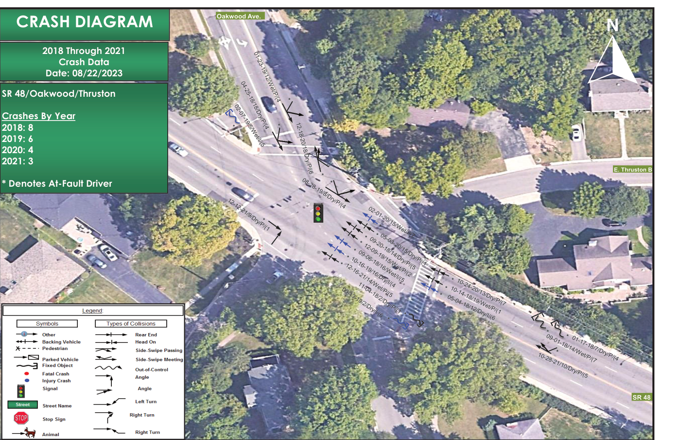
CRASH DIAGRAM
PROJECT FUNDING
| Project Phase | Safety Study | Interchange Mod. Study | PE - Environmental | PE - Detailed Design | Right of Way /Utilities | Construction | Total |
|---|---|---|---|---|---|---|---|
| Fiscal Year | 2023 | 2024 | 2025 | 2026 | 2027 | ||
| Project Phase Completed | N/A | $0.00 | |||||
| Previous Safety | $0.00 | ||||||
| New Safety | $50,000.00 | $450,000.00 | $170,000.00 | $4,305,109.00 | $4,975,109.00 | ||
| Sponsor Funding | $228,507.00 | $350,000.00 | $0.00 | $0.00 | $578,507.00 | ||
| Total | $228,507.00 | $0.00 | $400,000.00 | $450,000.00 | $170,000.00 | $4,305,109.00 | $5,553,616.00 |
Additional Application & Location Details (Highway Safety Improvement Program)
Highway Safety Improvement Program
Application Type: Formal Funding Application
Strategic Highway Safety Plan: Serious Crash Types — Intersection
Focus Area: Improving the design and operation of highway intersections / Intersection traffic control
FHWA Improvement Subcategory: Modify control - traffic signal to roundabout
Crash Totals & Analysis
Fatal & Serious Injury (KA): 0.1666
Visible Injury (B): 0.8344
Non-Visible (C): 1.3465
Property Damage Only (O): 4.3941
Total Crash Rate: 6.74
Observed People Injury Totals
K: 0.0000 | A: 0.5000 | B: 1.0000 | C: 1.0000 | Total: 2.50
Location & Corridor Data
Functional Class: 3 - Other Principal Arterial Roadway
Major Route AADT: 29,650
Active Transportation Need: 2 | Demand: 3
TOAST Score: 0.49
Location Termini: Intersection of Far Hills (SR-84) and Thruston/Oakwood
Logpoint: Begin 10.376 — End 10.376
Coordinates: Lat 39.728, Long -84.1790
Additional Funding & Economic Narrative
The City of Oakwood implemented a road diet on Schroyer Road using local funds in 2017 resulting in significant speed, crash, and severity reductions.
The proposed roundabout at the critical Five Points intersection will also enable the remainder of the SR48 corridor to effectively position for federal congestion and air quality funding by operating at lower cycle lengths in the future (see Table 8 and 9 of the operations study).