Smith Elementary
Suggested School Route Map
N
Accessible view
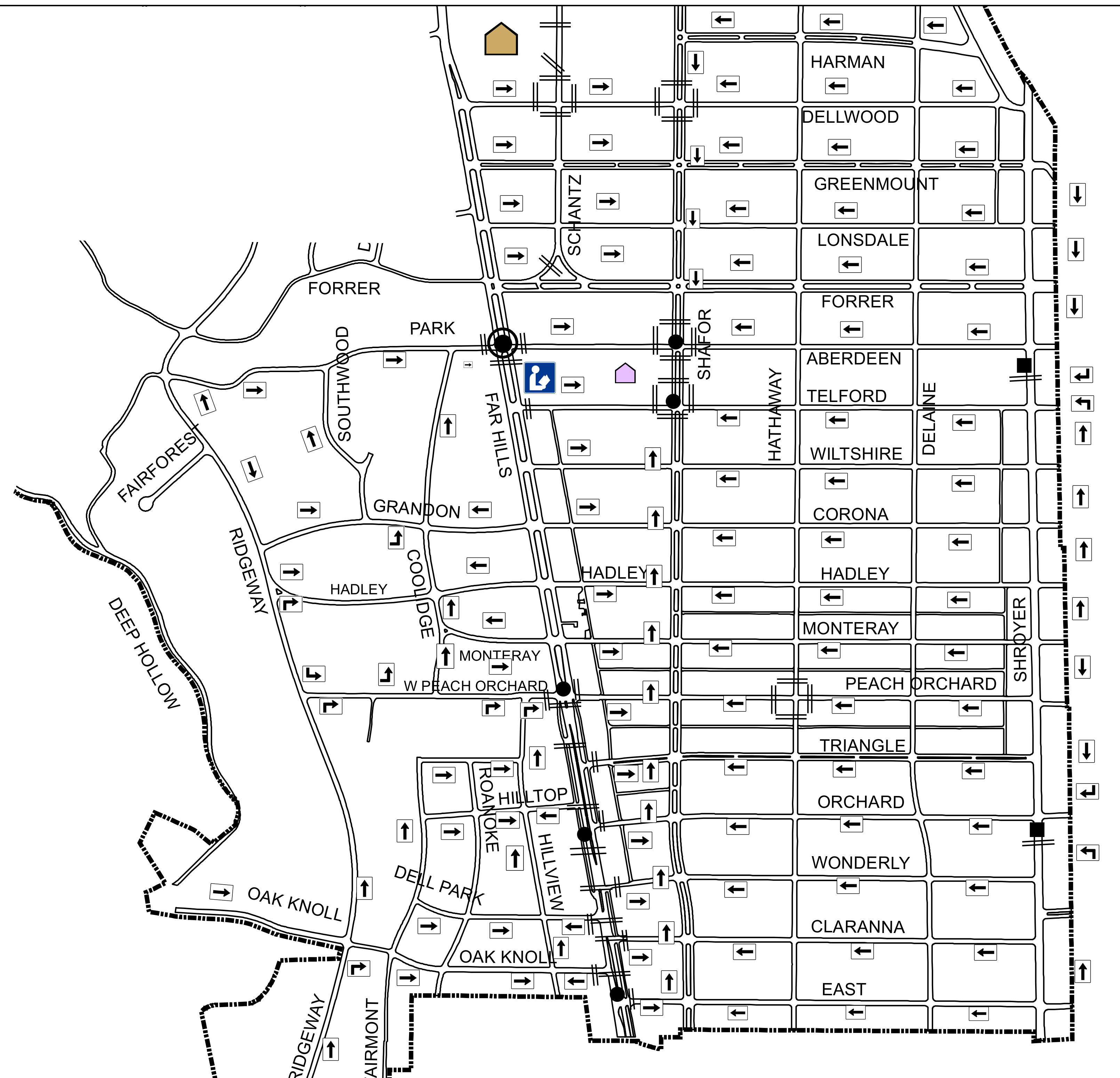
North is at the top of the map. The entries below are a text index of the marked route arrows and crossing symbols; direction is reported from the arrow on each segment rather than inferred from a general route.
Facilities and fixed landmarks
- Smith Elementary is the purple school symbol in the upper-central map, immediately east of the blue Wright Library marker on the short Park connection.
- Jr/ Sr High School is the tan school symbol at the north edge, north of Smith Elementary and Wright Library.
Marked route segments and turns
- Western approach: arrowed portions of Fairforest and Ridgeway lead toward the central streets and meet the Park/Grandon area. The map also marks route portions on Deep Hollow, Oak Knoll, and Del Park; their individual arrow boxes point along the connecting western roads.
- North and east grid: the horizontal segments on Harman, Dellwood, Greenmount, Lonsdale, and Forrer show left-pointing arrows (westbound). The same left-pointing treatment continues on Aberdeen, Telford, Wiltshire, Corona, Hadley, Monteray, Peach Orchard, Triangle, Orchard, Wonderly, Claranna, and East.
- Central connections: at the central junctions, the route turns between the horizontal streets and the marked north–south links, including Southwood, Stillwater, Schantz, Sherman, Coolidge, Roosevelt, Hillview, Hathaway, and Delane. The vertical arrow boxes show the direction for the particular block—upward or downward—so these are segment directions, not a claim that every connector is one-way.
- Readable branch order: follow the arrow boxes from Park to Grandon, then through Hadley and Monteray toward W Peach Orchard; the marked central network continues through Triangle → Orchard → Wonderly → Claranna → East. At every turn, leave the named horizontal street only where the adjacent north–south segment has a route arrow.
Crossings, treatment, and signal status
- A ring with a center dot means “Traffic Signal with Adult Crossing Guard.” These guarded crossings are marked on the central route corridor, including the Forrer-area junction beside the school and library markers and further south along the central links.
- A solid dot means “Traffic Signal” without the guard ring. The map places these at additional central-corridor crossings and at crossings on the eastern grid.
- Paired transverse lines are painted crosswalks. A solid black bar is a painted crosswalk with a crossing flasher. These treatments are shown at individual marked junctions along the central corridor and the eastern edge; use the symbol beside each crossing rather than treating every crossing as guarded or signalized.
The full-resolution map is available through the link below the graphic for closer inspection.