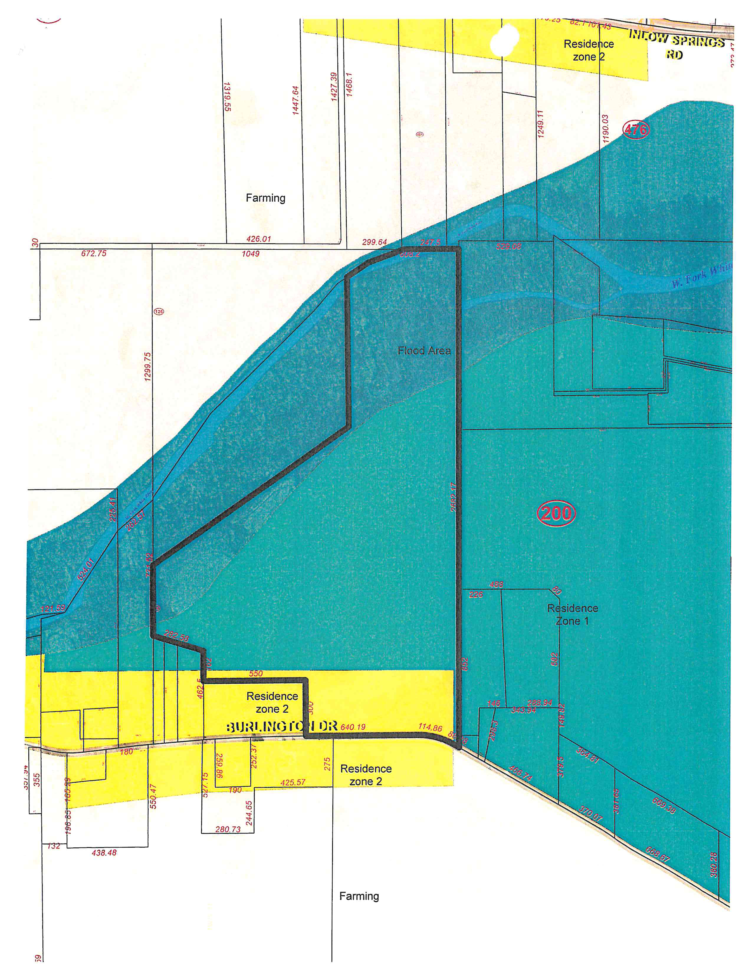
Plat map labels, parcel relationships, and dimensions
This structured view records the map labels, circled parcel identifiers, and dimension strings that are legible in the supplied image. Locations are described by their drawn relationship to the roads, colored areas, river, and adjoining boundaries; the full-resolution map image remains available for visual reference.
Named roads, water, and mapped areas
- BURLINGTON DR: The road label runs across the southern yellow band, with the large teal area immediately north of it and unshaded Farming below it.
- INLOW SPRINGS RD: The road label is at the upper-right edge, beside the yellow band and the northern parcel boundaries.
- W. Fork White River: The river label is within the dark blue-green corridor crossing the map from the central-left boundary toward the right edge.
- Flood Area: The label is inside the dark blue-green river corridor.
- Farming: The label appears in the unshaded tract north of the river corridor and again in the unshaded area south of Burlington Dr.
- Residence zone 2: The label appears in the yellow areas along Burlington Dr and at the upper-right edge.
- Residence Zone 1: The label appears in the large teal area east/southeast of the river corridor.
Circled parcel identifiers and their drawn locations
On narrow screens, each row presents the identifier and its map relationship.
| Identifier |
Relationship visible in the map |
| 126 |
Circled on the west side, beside the mapped boundary and river/flood corridor. |
| 451 |
Circled in the northern interior, above the east-west boundary and north of the river/flood corridor. |
| 476 |
Circled at the upper-right, near INLOW SPRINGS RD and the northern yellow band. |
| 200 |
Circled in the large teal area east/southeast of the river/flood corridor and north of BURLINGTON DR. |
Dimension strings grouped by drawn boundary (ft)
On narrow screens, each value is shown with its boundary relationship.
| Parcel or boundary relationship |
Exact dimension labels (ft) |
| Northern farming tract vertical boundaries, read left to right above the east-west boundary |
1319.55, 1447.64, 1427.39, 1468.1, 1249.11, 1190.03 |
| Upper east-west boundary north of the river/flood corridor, read left to right |
672.75, 1049, 426.01, 299.64 |
| West perimeter vertical boundary |
1299.75 |
| Main central north-south dividing boundary through the river/flood and teal areas |
2682.17 |
| BURLINGTON DR frontage segments along the yellow Residence zone 2 band |
550, 640.19, 114.86 |
| Southwest boundary lots along BURLINGTON DR |
438.48, 280.73, 425.57, 550.47 |
| Southeastern boundary segments in the teal Residence Zone 1 area |
456.74, 364.81, 370.07, 668.67, 669.38, 380.28 |