Site and Septic System Plan
Town of Goshen • Proposed House, Decks, Existing Garage & Septic Design
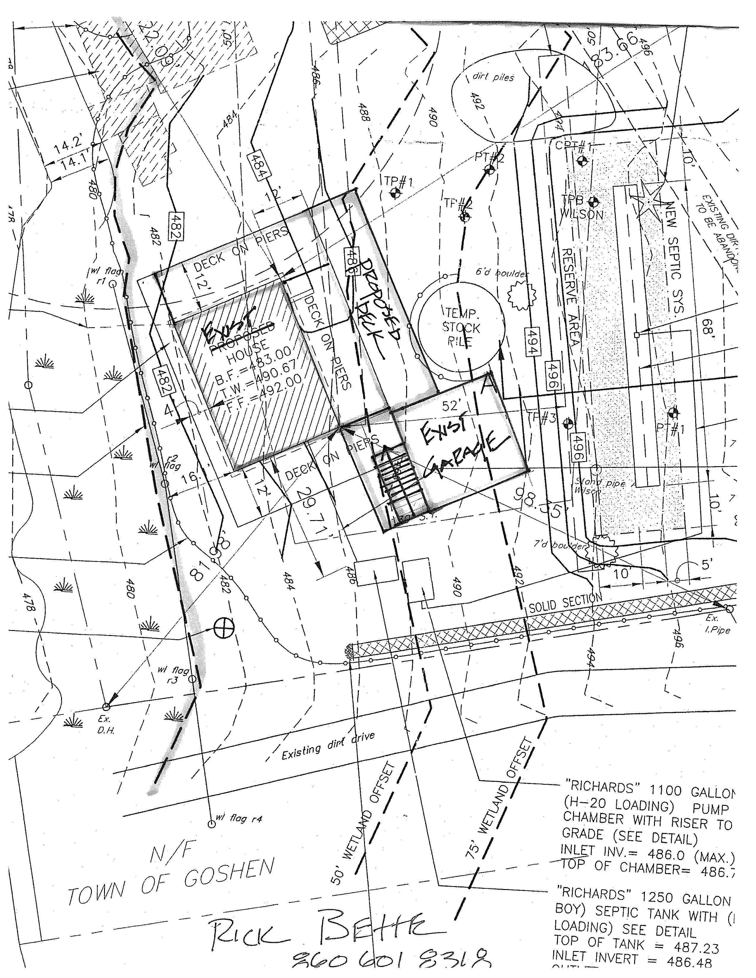
Proposed House & Deck Elevations
- B.F. (Basement Floor): 483.00′
- T.W. (Top of Wall): 490.67′
- F.F. (First Floor): 492.00′
- Structure Features: Proposed House (marked “EXIST” overlay), Deck on Piers, Proposed Deck addition, Existing Garage (52′ wide)
Septic System Specifications
- Septic Tank: “RICHARDS” 1,250 Gallon (H-20 Loading) Septic Tank with Riser to Grade (see detail)
- Top of Tank = 487.23′
- Inlet Invert = 486.48′
- Pump Chamber: “RICHARDS” 1,100 Gallon (H-20 Loading) Pump Chamber with Riser to Grade (see detail)
- Inlet Inv. = 486.0′ (Max.)
- Top of Chamber = 486.7′
- System Components: New Septic System, Reserve Area, Stand Pipe, Solid Section pipe
- Plan callouts: NEW SEPTIC SYSTEM and RESERVE AREA
Environmental & Boundary Details
- Offsets: 50′ Wetland Offset line, 75′ Wetland Offset line
- Wetland Flags: wl flag r1, wl flag r2, wl flag r3, wl flag r4
- Abutters: N/F Town of Goshen
- Access: Existing dirt drive
- Stockpile: Temp. stock pile, dirt piles
- Plan labels: Solid Section, Stand Pipe, Ex. 1-Pipe
Field Notes & Contacts
- Handwritten Contact: Rick Behr — (860) 601-8318
- Test Pits / Borings: TP #1, TP #2, TP #3, PT #1, PT #2
- Features: 6′d boulder, 7′d boulder, Ex. D.H., Ex. 1-Pipe
- Additional field labels: TP #1, TP #2, TP #3, PT #1, PT #2
Accessible view
Accessible plan transcription: This is a black-and-white engineering site-plan sheet. The sequence below follows the visible sheet from upper/left to lower/right. Abbreviations are retained rather than expanded; a few small or overlapped marks are identified as uncertain instead of being interpreted.
House, decks, and existing garage — center-left
- The main hatched structure is labeled PROPOSED HOUSE. Its interior elevation notes read B.F. = 483.00′, T.W. = 490.67′, and F.F. = 492.00′.
- Deck areas around the house are labeled DECK ON PIERS. A separate deck callout near the house reads PROPOSED DECK in the source image. Dimension marks in this group visibly include 21′, 16′, 12′, 8′, and 7′; the leader-line endpoints are not all unambiguous at page scale.
- Below and to the right is the existing garage area, with a visible 52′ dimension. The handwritten/overprinted garage notation is read as Exst/Exst Garage; the exact lettering is not fully clear.
- Nearby feature labels include 6′ d boulder and 7′ d boulder.
Reserve area and septic system — right side
- RESERVE AREA is shown immediately left of the vertical area labeled NEW SEPTIC SYSTEM. A stand-pipe/solid-pipe callout is visible near this area; its exact punctuation is not clear.
- The lower-right printed note is read as: “RICHARDS” 1,100 GALLON (H-20 LOADING) PUMP CHAMBER WITH RISER TO GRADE (SEE DETAIL); INLET INV. = 486.0′ (MAX.); TOP OF CHAMBER = 486.7′.
- A second printed note is read as: “RICHARDS” 1,250 GALLON (H-20 LOADING) SEPTIC TANK WITH RISER TO GRADE (SEE DETAIL); TOP OF TANK = 487.23′; INLET INVERT = 486.48′. The tank-note line immediately after “WITH” is partly obscured in the source image, so “riser to grade” is retained as the apparent reading from the callout and not expanded further.
- Other numeric marks in the septic/right-side group visibly include 68′, 10′, and 5′. Their exact reference features are conveyed by the drawing’s leaders and cannot all be reproduced in linear text.
Contours, boundaries, wetland offsets, and access
- The plan has contour/elevation numerals that can be read as 480, 482, 484, 486, 488, 490, 492, 494, and 496. These are shown along the contour lines across the site; not every fine contour label is legible in the supplied page image.
- Two diagonal lines are labeled 50′ WETLAND OFFSET and 75′ WETLAND OFFSET. Wetland flags are labeled wl flag r1, wl flag r2, wl flag r3, and wl flag r4.
- The lower-left property annotation reads N/F TOWN OF GOSHEN. Dashed property/boundary lines and their witness/leader marks cross the lower portion of the sheet.
- The lower-center access route is labeled Existing dirt drive. Along and beside it are the utility/edge labels SOLID SECTION, Ex. 1-Pipe, and Ex. D.H.
- Additional visible dimension marks near the upper-left boundary read 4.2′ and 4.7′. A small boundary-area note near the septic system appears to contain “... BOUNDARY,” but the complete wording is illegible.
Test pits, field marks, and notes
- Test/field-point labels visible around the house and septic area include TP #1, TP #2, TP #3, PT #1, and PT #2. The source uses both “TP” and “PT”; they are not normalized here.
- The upper part of the site includes a circular note TEMP. STOCK PILE and a separate note dirt piles.
- A label near the upper-right reserve area appears to read PB WILSON; the lettering and its meaning are not sufficiently clear to expand.
- The handwritten note at the bottom reads Rick Behr and 860 601 8318.
Reading note: The source image remains the authoritative visual reference for exact line geometry, leaders, symbols, and the placement of each label. Text that is too small or overlapped to read confidently has not been guessed.