Metropolitan Planning Area Map
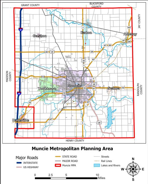
DMMPC Metropolitan Planning Area (MPA): An MPA refers to the official geographic region where an MPO carries out its federally mandated transportation planning and funding programs. Shown in the figure below, the MPA for our MPO includes all of Delaware County except Daleville and its surrounding area which are included in the Anderson urbanized area.
Accessible view
Map title: Muncie Metropolitan Planning Area.
MPA boundary and area: The red boundary marks the Muncie Metropolitan Planning Area in Delaware County. It includes all of Delaware County except Daleville and its surrounding area, shown in the southwest; that area is included in the Anderson urbanized area.
Labeled communities:
- Gaston, Eaton, and Albany are labeled across the north.
- Yorktown, Muncie, and Selma are labeled across the central area.
- Daleville is labeled in the southwestern excluded area.
County context: The surrounding county labels are Grant County, Blackford County, Jay County, Madison County, Randolph County, and Henry County.
Transportation and map features: Major routes are drawn with route shields and labels, including I-69 and 3, 28, 32, 35, 67, and 332. The legend, headed “Major Roads,” identifies Interstate, US Highway, State Road, Major Road, and Muncie MPA; it also identifies Streets and Rail Lines. Cyan lines and shapes show the legend category “Lakes and Rivers.”
Orientation and scale: A compass marks north, east, south, and west. The scale bar is marked 0, 2.5, 5, and 10 Miles.