Mobility Framework
Streets are envisioned not just as infrastructure, but as shared public spaces that create a seamless transit experience and foster greater social connectedness. The mobility framework prioritizes breaking down large blocks to make the site walkable and welcoming to the neighborhood.

Keep Cars on the Perimeter
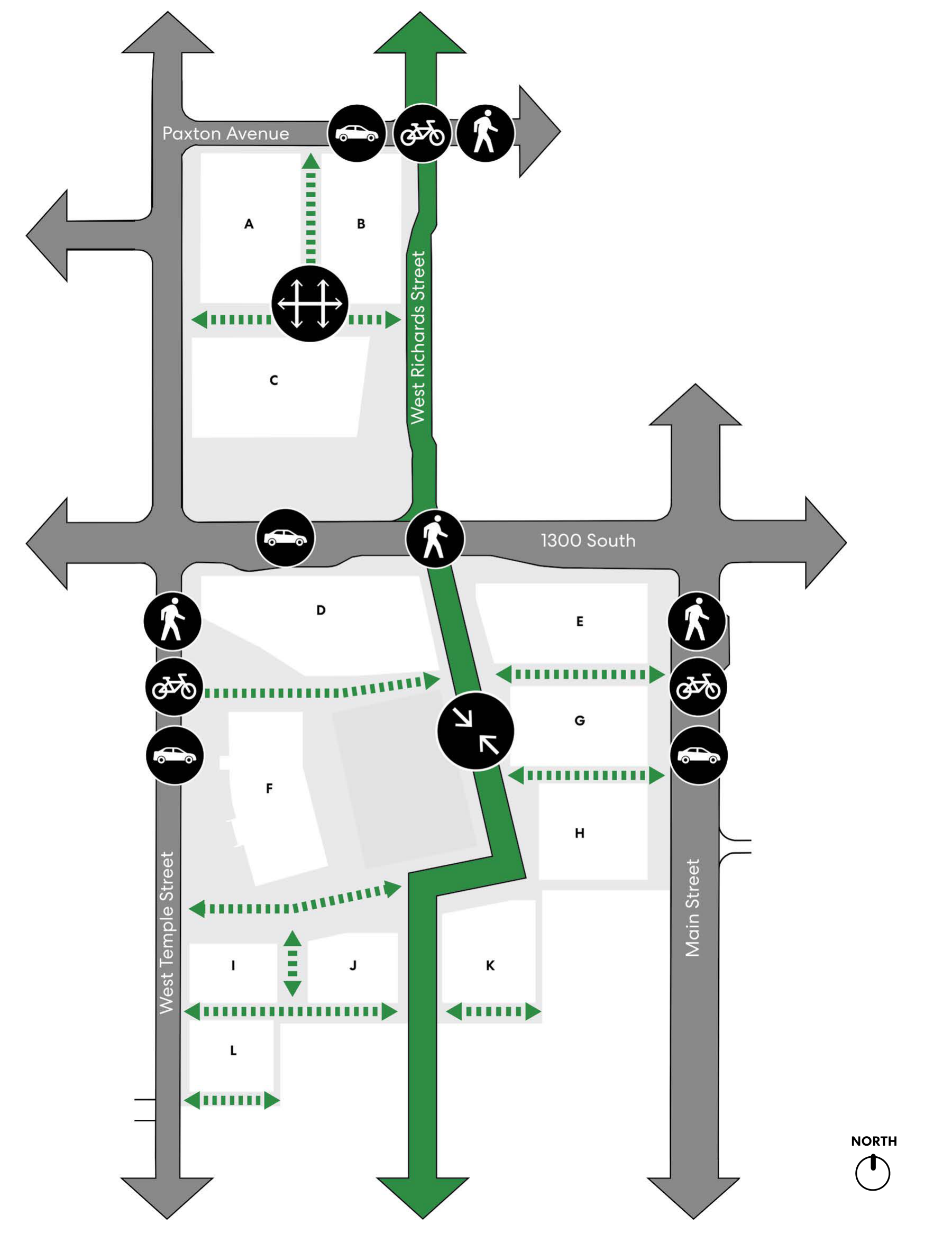
Vehicle access is concentrated along the site’s perimeter - 1300 South, Main Street, Paxton Avenue, and parts of West Temple—preserving interior streets as pedestrian-priority zones.

Break Up the Super Block
By opening the edges and inviting the pedestrian to traverse the site through a series of connected alleyways and walkways, the super block is broken down into smaller pieces. This intentional porosity encourages walking and biking through the neighborhood as well as informing the scale and form of new buildings.

Reconnect Richards Street
Restitching the fragmented segments of Richards Street creates a key north-south pedestrian link through the site’s mid-block.

Integrate Pedestrian and Bicycle Infrastructure
The proposed bike infrastructure within the Ballpark site aligns with the Ballpark Station Area Plan, which recommends bike routes along Main Street and Paxton Avenue. Additionally, the West Temple Festival Street will provide a comfortable and accessible north-south bikeway. Interior streets throughout the site are intentionally designed to promote walking and biking, creating a safe and inviting environment for active transportation.
Scroll horizontally to inspect the map.
Map route description
Parcels A, B, and C lie north of 1300 South; parcels D through L lie south of it. Paxton Avenue forms the north edge, West Temple Street the west edge, and Main Street the east edge. West Richards Street is the solid green route: it enters from Paxton Avenue between parcels A and B, crosses 1300 South, angles southeast through the central blocks, bends west near parcels G and H, then continues south between the lower blocks to the map’s southern edge. Green dashed arrows mark two-way paths through the interior blocks, including a north–south link between A and B, crossing links at A/B/C and among parcels D through L, and a diagonal link from West Temple Street toward the bend in Richards Street.
Broad gray arrows show the directions of the four surrounding streets. Black circular mode symbols are placed along Paxton Avenue (car, bicycle, pedestrian); along 1300 South (car and pedestrian); and in vertical groups on West Temple Street and Main Street (pedestrian, bicycle, car). A four-direction symbol marks the crossing between parcels A–C, and a paired inward-arrow symbol marks the Richards Street bend near parcels G–H. The NORTH compass points toward the top of the map.