Service and Access
While prioritizing pedestrian movement, the framework ensures interior roadways can accommodate vehicles, meeting fire requirements and providing clearly demarcated areas for service, parking, and pick up/drop off.
Emergency Access Streets
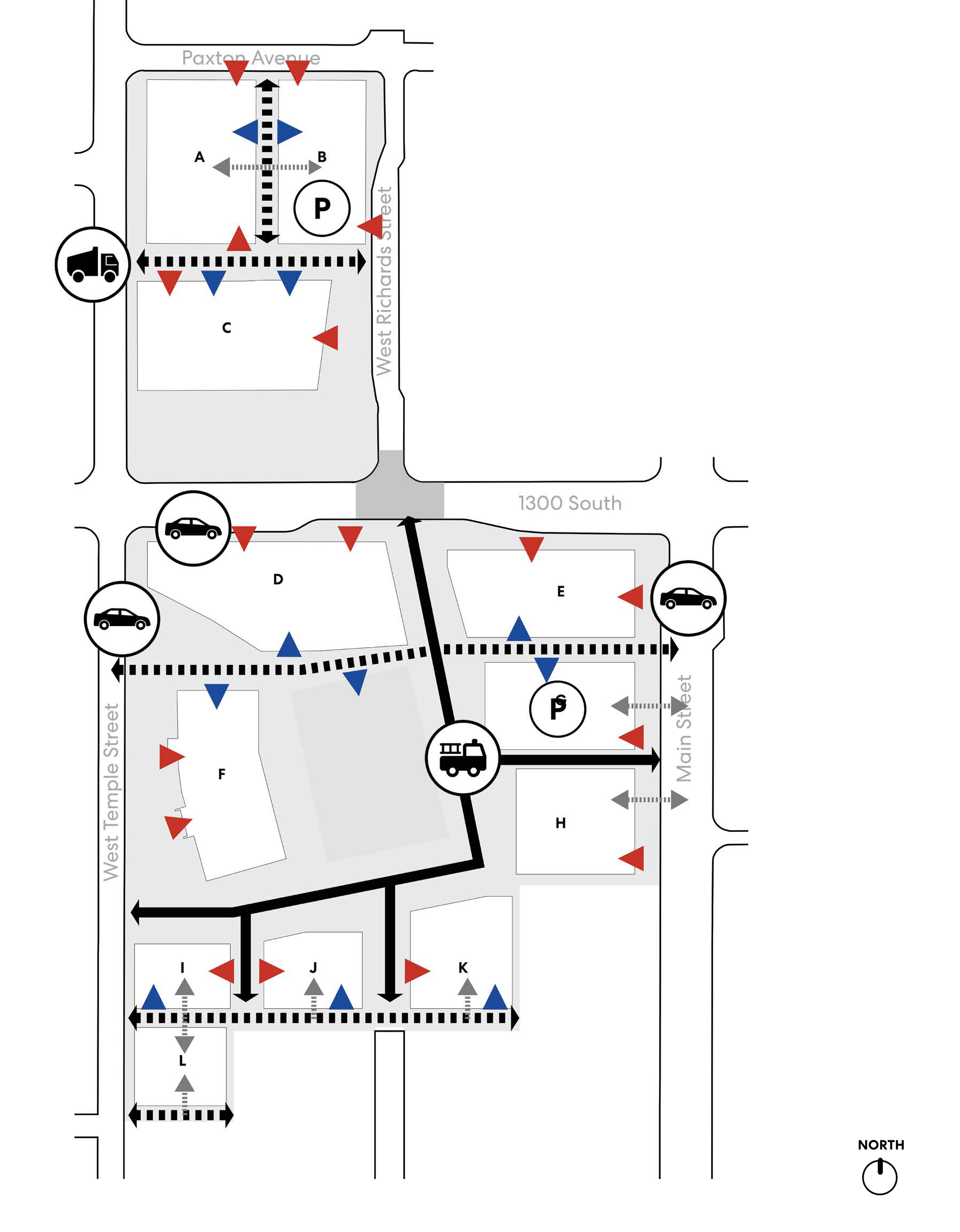
The internal roadways are designed for everyday use but built to support fire access when needed. The Park Promenade and Shared Pathways are designated as emergency access streets with the appropriate width for fire access. The approximate roadway width for emergency access streets is 40 feet.
Service Streets
These are shared streets with appropriate width for garbage trucks and other service vehicles. The approximate roadway width for the service streets is 30 feet.
Shared Parking Garages
Two shared parking garages are located on either side of 1300 South. Parking Garage South has access from Main Street and Parking Garage North has access from mid-block service street.
Service and Lobby Entries
Main Street provides direct vehicular access for Fire Station 8.
All service entries are sited on service streets along the backside of new development.
Lobby entries are primarily sited along existing roadways like West Temple Street, 1300 South, Main Street, Richards Street, and Paxton Street. However, multi-family housing blocks have lobby entries along the shared streets and/or alleyways.
Designated Pick-Up/Drop-Off
Designated pick-up/drop-off areas for events are located on West Temple, 1300 South, and Main Street.
Scroll horizontally to inspect the map.
Service and Loading
- Emergency Access Streets
- Service Entries
- Lobby Entries
- Service Streets
- Pick-Up/Drop-Off
- Vehicle Access
- Parking Garages
Diagram description
Circled P symbols place shared parking garages in block B, north of 1300 South, and block G, south of it. Circled vehicle symbols mark pick-up/drop-off on West Temple Street, 1300 South, and Main Street. North is shown at the lower right.
- Emergency access streets use black dotted routes. A north–south route runs between A and B and meets a cross route along the south edge of A/B and north edge of C. Farther south, another cross route links the shared D/E-to-F path; a lower cross route runs along the south side of I, J, and K.
- Service streets use thick solid black routes. A connected middle spine runs diagonally through the center of the plan, continues east of F, and connects with the route along the northern edge of the lower parcels; north–south links serve the lower parcels.
- Vehicle access is marked by gray dotted double arrows between A and B, along the east-side street by G and H, and within the lower I–L block network.
- Entry markers are red triangles for lobby entries and blue triangles for service entries. The red markers face perimeter streets and internal shared streets; the blue markers face the rear service streets and shared service routes. The accompanying text specifies that service entries are along service streets at the backs of new development, while lobby entries are primarily on West Temple Street, 1300 South, Main Street, Richards Street, and Paxton Street, with multi-family blocks also using shared streets and/or alleyways.